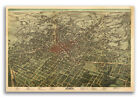
Vintage Railroad Map "map Of The East Tennessee, Virginia & Georgia..." 1885

Sold by valuablethings
This seller has received 6,385 ratings (100.00% Positive)
Buy now for $9.99 USD
Item ships from Easton MD USA
Browse all: North America Maps
Similar Items


$11.44 USD Buy It Now
Vintage GEORGIA Railroad Map Wall Art Old Original Atlanta Savannah DATED 1914


$5.00 USD Buy It Now
1885 ENCYCLOPAEDIA BRITANNICA MAP-THE ENGLISH COLONIES & NORTH & SOUTH VIRGINIA


$7.99 USD Buy It Now
Antique Post World War WWI 1924 World Atlas City Map Atlanta Georgia GA Railroad

$9.99 USD Buy It Now
ANTIQUE 1889 NEW ORLEANS LOUISIANA & ATLANTA GEORGIA MAP HORSE RAILROAD FINE RAR


$18.82 USD Buy It Now
Vintage VIRGINIA Railroad Map LARGE Southern Railway Original Lynchburg Antique

More from valuablethings


$9.99 USD Buy It Now
Vintage Railroad Map "Map of the Illinois Central R. R. and Connections" 1885 (326440986610)

$9.99 USD Buy It Now
Vintage Map From the Plat of U.S. Reservation, No 7, Mare Island (326441600911)


$9.99 USD Buy It Now
Vintage Map "Salem Harbor Including South River Massachusetts" 1888 (326423644312)


$9.99 USD Buy It Now
Vintage "Pre Chart No 3 Sea Coast of the U.S. Cape Small Point to Cape Cod" (326407901751)


$7.49 USD Buy It Now
Vintage Map, "North America Bureau of American Ethnology Progress Map" 1900 (326297326470)

$7.49 USD Buy It Now
Vintage Engravings From A. DE La Motraye's Travels Through Europe... (325879121807)

$7.49 USD Buy It Now
Antique "Map of the Ft Hall Indian Reservation, Idaho" Free Shipping (325729163638)


$7.49 USD Buy It Now
Vintage Map "York River in the Vicinity of West Point, Virginia" (325505186427)

$7.49 USD Buy It Now
Vintage Map "Miss. River from Meramec River to Calico Island" 1889 (325501432502)

$7.49 USD Buy It Now
Antique Map "Map showing the present condition of Fort Miami, Ohio." (325550977850)

$7.49 USD Buy It Now
Vintage Map "Arizona" 1893 Columbian World's Fair Atlas, Chicago (325917570961)


$7.49 USD Buy It Now
Vintage Map "Map of Ohio" For Poor's Manual of Railroads for 1885 (325876856846)


$7.49 USD Buy It Now
Antique Sketch of a portion of SE California Showing Depressed Area Colorado De (325876854765)

$7.49 USD Buy It Now
Vintage Map "Louisiana" 1893 Columbian World's Fair Atlas, Chicago (325917570686)

$7.49 USD Buy It Now
Vintage "Map of the Carrollton Channel Saginaw River, Michigan, showing dredging (325543009914)


$7.49 USD Buy It Now
Vintage Map "Field of Cavalry Operations East of Gettysburg July 2 & 3rd, 1863" (325897592857)


$7.49 USD Buy It Now
Vintage Maps (2) North America by Edward Weller, Commerical & Physical (325876856411)

$7.49 USD Buy It Now
Vintage Map "Entrance to Sabine Pass, Texas Showing Progress of Improvement" (325548296727)

$7.49 USD Buy It Now
Vintage Map "Western Minnesota, showing Water-Shed of Red Lake... (325543009783)


$7.49 USD Buy It Now
Vintage "No. 5 Chart of the Head of Passes Mississippi River showing Jetties... (325545812452)


$7.49 USD Buy It Now
Vintage Map, "U. S. Coast Survey Romer and Flynn's Shoals, New York Bay" (325800728611)

$7.49 USD Buy It Now
Vintage Map, "Contour Chart of the Atlantic Ocean from Soundings to 1874" (325800728906)


$7.49 USD Buy It Now
Vintage Map, "Northern & Eastern Part of Maine and part of Lower Canada and New. (326297327933)

$4.99 USD Buy It Now
Survey for Railroad, Geological Plan From Rio Grande to Pimas Villages (326192460741)

$4.99 USD Buy It Now
Antique Map "Map of Franz Joseph Land, illustrating An Account of the Austro-" (324925979733)


$4.99 USD Buy It Now
Antique Map "Diagram of the Surveying District South of Tennessee" (325460168167)


$4.99 USD Buy It Now
Vintage Map "Olympic Forest Reserve, Washington, Hemlock to the forest" 1899 (326119951983)

$4.99 USD Buy It Now
Vintage Map "Newburyport Harbor, Mass Plan Showing Condition of Improvement... (325881894249)


$4.99 USD Buy It Now
Vintage Map "Map of Drift & Glacier Striaf. & Moraines in Massachusetts 1856" (326104337317)

$4.99 USD Buy It Now
Antique Map "California, Nevada, Oregon, Washington, Idaho, Utah, Arizona and... (324854652984)


$4.99 USD Buy It Now
Vintage Map, "Sketch of a Rec. to the Mining Regions of Clarks Fork...Yellow Sto (325814113008)

$4.99 USD Buy It Now
Antique Map "No. 1.....Delaware Breakwater Harbour In the Years 1833, 34 & 36... (325450050234)


$4.99 USD Buy It Now
Antique Map "Plan and Elevation of Draw-Bridge Piers... Falls of the Ohio." (325232109363)

$4.99 USD Buy It Now
Vintage Map "1889 Flushing Bay, N.Y. Condition of Improvement June 30, 1889" (325881895230)

$4.99 USD Buy It Now
Vintage Map "Olympic Forest Reserve, Washington, Cedar to the forest" 1899 (326119952055)

$4.99 USD Buy It Now
Antique Map "U.S. Coast Survey Sketch F Showing the Progress of Survey Sec VI (324534010660)

$4.99 USD Buy It Now
Vintage "Map of Tallmadge Township" & "Tallmadge Center" Summit County, Ohio (326356390058)

$4.99 USD Buy It Now
Antique Map, "York River in the vicinity of West Point, Virginia" 1884 (326167971438)


$6.99 USD Buy It Now
Two Maps Florida Key West St. Johns River Surveys 1896 Free Ship (326051282576)


$34.99 USD Buy It Now
Original Colton Canada Maps Large Format Hand Colored 1870 (4 Individual Maps) (326424807345)

$3.99 USD Buy It Now
Antique Map "U.S. Coast Survey Approx Cotidal Lines Gulf of Mexico Diurnal & Se" (325410421554)

$3.99 USD Buy It Now
Antique Map "U.S. Coast Survey Lines of Equal Magnetic Declination for....1850" (325410420487)


$3.99 USD Buy It Now
Antique "Part of the River Tabasco and its Tributaries to illustrate the paper.. (325201208838)


$3.99 USD Buy It Now
Vintage Map "Improvement of St. John's River Florida, showing the sites of the.. (325427637244)

$3.99 USD Buy It Now
Vintage "Map of Lake Champlain at Four Channels, New York." 1885 (325692452297)

$3.99 USD Buy It Now
Antique Map "U.S. Coast Survey Type Curves of Tides in the Gulf of Mexico" (325411672734)

$3.99 USD Buy It Now
Antique Map "U.S. Coast Survey Diagrams Qty of Winds Month Cat Island Miss Sd" (325411672806)

$3.99 USD Buy It Now
Vintage "Map Showing location of Proposed Reservoirs on Gull Lake & Pine River (325692452638)

$3.99 USD Buy It Now
Antique Map "U.S. Coast Survey Diagrams of Heights & Lunitidal Intervals of... (325410421473)

$9.00 USD Buy It Now
Original Map Report Charleston Harbor Jetties South Carolina 1881 FREE SHIP (326079164013)


$9.00 USD Buy It Now
Antique "Map of The City of New York (Greater New York) and Vicinity" (325738690764)


$6.49 USD Buy It Now
Original Map St. Mary’s River Lake George Michigan Scarce 1858 FREE SHIP (326160661078)

$6.49 USD Buy It Now
Original Map St. Mary’s River Lake George Michigan Scarce 1858 FREE SHIP (326160650695)

$6.49 USD Buy It Now
Antique Civil War Map, Comte, "Field of Cavalry Operation East of Gettysburg" (326353607024)

$6.49 USD Buy It Now
Antique Map "Geographical Position Rail & Water Communications Arsenal East Of (324688412798)


Whohou Marketplace | Terms of Use | Privacy Policy | Contact Us | Follow us on Facebook, Instagram, and Twitter | Affiliate Program | Affiliate Portal